
Odin
Launch: February 20, 2001
Status: Active
The Odin satellite was launched in February 2001 from Svobodny, in eastern Siberia. Originally planned for a two-year mission, it continues to orbit 600 km above Earth, collecting measurements that are extremely valuable for studying climate and long-term changes in the atmosphere.
Canada's instrument – OSIRIS
Canada's Optical Spectrograph and InfraRed Imaging System (OSIRIS) is the optical payload on Sweden's Odin satellite. It works in synergy with Sweden's advanced radiometer and measures atmospheric composition.
Since 2001, OSIRIS has obtained valuable information on the upper atmosphere. It focuses its attention on altitudes from 7 to 90 km—between the highest mountains and the edge of space—and measures concentrations of ozone, aerosols and nitrogen dioxide.
Data provided by OSIRIS helps scientists better understand the impact of human activities and natural phenomena on the environment and climate.
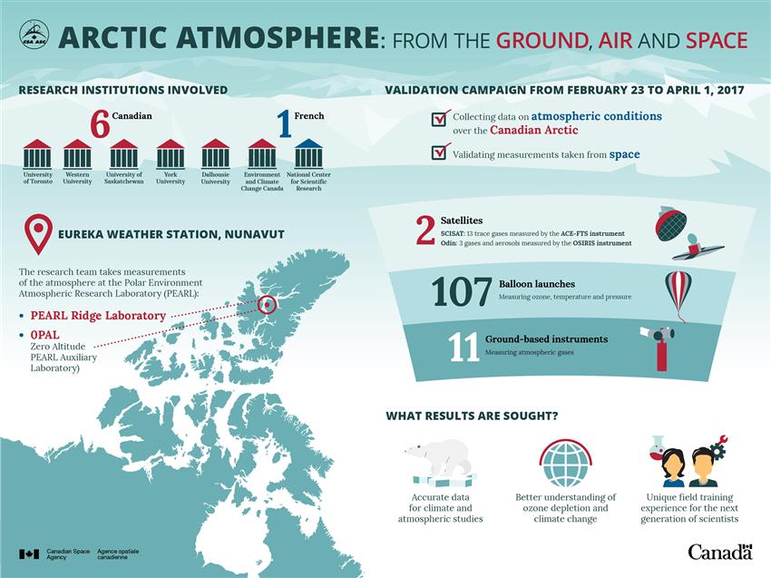
Text version - Arctic atmosphere from the ground, air and space
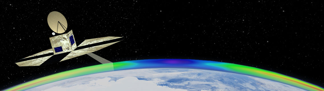
- validation campaign - Science team heading North to study the Arctic atmosphere and validate satellite data. (Credit: Canadian Space Agency)

OSIRIS (Credit: University of Saskatchewan)
Monitoring signs of climate change from space
Climate change is one of the greatest threats of our time. Space-based instruments like OSIRIS are valuable tools for studying various aspects of the Earth and atmosphere and support evidence-based decision making at the highest levels.
Canada's OSIRIS instrument has been measuring and mapping ozone and detecting aerosols and nitrogen dioxide in the atmosphere since 2001—longer than any other currently operational space instrument. The long duration and consistent quality of OSIRIS measurements are internationally recognized and used to validate and improve climate models worldwide. The resulting datasets have historical value and play an important role in international efforts like the ESA Climate Change Initiative and are used in the Intergovernmental Panel on Climate Change (IPCC) and the World Meteorological Organization (WMO) ozone reports, to name a few.
Monitoring the ozone layer from space (Credits: Canadian Space Agency, University of Saskatchewan)
Understanding ozone
Ozone molecules in Earth's atmosphere shield the surface of the Earth from a large percentage of the Sun's harmful ultraviolet rays. Keeping the ozone layer healthy is essential for sustaining life on Earth.
OSIRIS has been providing daily, monthly, and annual measurements of the ozone layer since 2001. The data shows that the ozone layer has been stabilizing gradually since the 1987 Montreal Protocol on Substances that Deplete the Ozone Layer—often described by the international community as one of the most successful international agreements to date. Steady progress has been made under the Protocol: The rate of ozone depletion slowed between 1995 and 2000 and is now showing signs of recovery.
The "ozone hole" continues to appear over the South Pole every spring, but it is no longer getting larger.
Ozone-depleting substances such as chlorine-containing gases react and destroy ozone molecules under the right sunlight conditions. The conditions for extreme ozone destruction, leading to what is commonly known as the "ozone hole," are generally present only during the spring season over the South Pole.
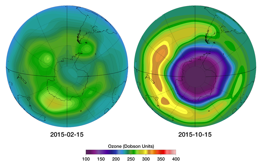
Typical seasonal variations of ozone concentration over the South Pole. The left image shows higher concentrations of ozone in February 2015, and the right image shows very low ozone concentrations, the "ozone hole," in October 2015. (Credit: CSA, University of Saskatchewan)
Surprising ozone depletion over the Canadian Arctic
OSIRIS measured an unexpectedly large reduction in ozone over the North Pole for the first time in 2011. The explanation: stratospheric temperatures in the spring allowed chlorine-containing gases to react more strongly and destroy more ozone molecules than usual. Thankfully, such low concentrations have not been observed since.
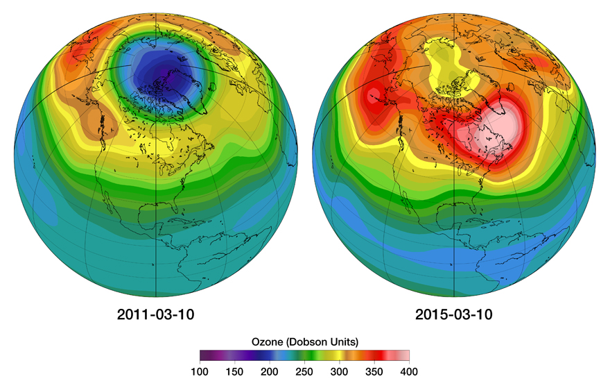
The first ozone hole over Canada. On the left, very low ozone concentrations were measured over the North Pole in March 2011. The typical ozone concentration levels measured over Canada in the spring are illustrated in this image from March 2015. (Credit: CSA, University of Saskatchewan)
Aerosols and global cooling
Aerosols also play an important role in Earth's climate, reflecting or absorbing sunlight.
Did you know that a volcanic eruption can lead to a temporary drop in global temperatures?
When a volcano erupts, the concentration of aerosols in the stratosphere increases. These aerosols can remain in the stratosphere for months and even years, causing worldwide temperatures to drop during this period because of the way these tiny particles reflect sunlight.
A real-life example: When the Nabro Volcano erupted in June 2011, OSIRIS measured a significant increase in aerosols, first over Asia but eventually around the Northern Hemisphere, including over Canada. OSIRIS has measured the impact of nine volcanic eruptions like this since the beginning of its mission.

Eruption at Nabro Volcano. The Nabro Volcano, along the border between Eritrea and Ethiopia, emitted a thick plume of volcanic gases on June 15, 2011. (Credit: NASA / Aqua – MODIS)
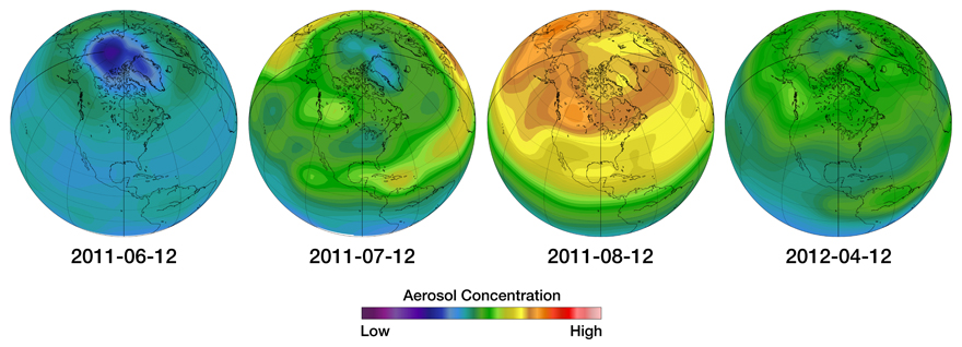
Aerosol concentrations over Canada following the July 2011 Nabro Volcano eruption. This series of images illustrates the changing concentration of aerosols over Canada, as measured by the OSIRIS instrument in 2011 and 2012. From left to right: low concentration of aerosols are measured just before the Nabro eruption; higher concentrations mostly over Asia about a month later; higher concentrations spread throughout the Northern Hemisphere by stratospheric winds two months after the eruption; and finally, after ten months, a return to pre-eruption levels with some residual remaining. (Credit: CSA, University of Saskatchewan)
Successful partnership
In addition to providing high-quality data for climate science, OSIRIS is an excellent example of collaboration at both the national and international levels.
The Odin satellite is the third joint mission between Canada and Sweden. Satellite operations are the responsibility of the Swedish National Space Board, and OSIRIS operations are funded by the Canadian Space Agency. The mission is also supported through the European Space Agency's Third Party Mission program.
OSIRIS was designed and built by Routes AstroEngineering, a space-engineering firm based in Kanata, Ontario, and the Canadian science team is led by the University of Saskatchewan. Environment and Climate Change Canada's Air Quality Research Division is also studying OSIRIS data on nitrogen dioxide concentrations to improve forecasting of surface-level air pollution.
Since his retirement, the original Principal Investigator, Dr. E. Llewellyn of the Institute of Space and Atmospheric Studies at the University of Saskatchewan, was replaced by Professor Doug Degenstein in 2007. Professor Degenstein is supported by two instrument co-investigators: Professor Adam Bourassa, University of Saskatchewan; and Dr. Chris McLinden, Environment and Climate Change Canada.
Explore further
- Date modified: