
Recent projects – Earth observation application development

Exploring the benefits of using satellites and drones together
- From their unique vantage point in space, Earth observation (EO) satellites provide data that is used to support activities and decision making in various areas, helping us monitor and protect our environment, improve resource management, and maintain safety and security. As satellite technology advances, the potential uses and applications for their data are also improving.
Unmanned aerial systems (UASs), or drones, have also evolved significantly in recent years. They are increasingly available and used in a wide variety of domains. Applications include agriculture, environment, infrastructure and natural resources, to name just a few.
With the rise and popularization of this technology, the Canadian Space Agency (CSA) is interested in exploring the complementary use of drones and satellites to enhance EO applications and provide more comprehensive solutions to end-users. Through its Earth Observation Application Development Program (EOADP), the CSA is funding the following concept studies. Each project, which benefits from a maximum funding of $100,000, is proposing an innovative EO solution that incorporates the use of drones.
| Application | Concept study | Company |
|---|---|---|
| Identifying the presence of pests in agriculture | Use drones to perform more precise screening of pests in agriculture. Automated screening by drones would be guided by risk maps that identify presence of pests using satellite data. The concept could contribute to more strategic use of agricultural inputs (e.g. pesticides). |
effigis Géo-solutions inc. (Montreal, Quebec) |
| Monitoring algae blooms | Monitor algae blooms (cyanobacteria / blue-green algae) in an orderly and cost-effective manner by using hyperspectral sensors aboard drones to simulate coarse-resolution data for specific regions. |
INRS centre ETE (Quebec City, Quebec) |
| Monitoring algae blooms | Use data from EO satellites along with hyperspectral and thermal infrared sensors aboard drones to identify non-toxic and toxin-producing algae in local waterways. The concept could support early warnings and help reduce risk of health consequences. |
H20 Geomatics (Waterloo, Ontario) |
| Providing land measurements to the mining sector | Investigate the benefits of using drone-derived digital elevation model products to ensure quicker delivery and increased accuracy of land measurements for the mining sector. |
TRE Altamira (Vancouver, B.C.) |
| Detecting disturbances caused by industrial activities | Combine the advantages of EO satellites and drones to monitor industrial disturbances caused by oil and gas exploration and development. Enhance information products developed from satellite data by using drones where satellites do not provide sufficient resolution (e.g. to observe narrow linear disturbances). |
ASL Environmental Sciences (Victoria, B.C.) |
| Monitoring pipelines | Develop a complete operational definition for remote pipeline monitoring. Examine recent results using satellite data, and define a technically feasible concept that incorporates drones while considering current and potential regulation of drones by Transport Canada. |
C-CORE (St. John's, Newfoundland) |
| Monitoring forests | Develop a cost-effective method that uses EO data to produce maps that show the infestation, defoliation and mortality of spruce trees caused by the growing presence of pests like the spruce budworm, particularly in the boreal forests of northern Quebec. |
AECOM Consultants Inc. (Quebec City, Quebec) |
Using satellite data to enhance disaster management in Canada
- Over the years, Earth Observation (EO) has proven to be a valuable tool to monitor and assist during critical situations disrupting our environment. From a distance, EO satellites are consistently giving us a global view of our vast country, precisely measuring minute changes in our territory hence providing us with important information, particularly in times of disaster management.
Recognizing the rapid growth of technology and our increasing need for more innovative tools taking full advantage of the EO information available, especially in the context of catastrophic situations, the Canadian Space Agency (CSA) recently issued a Request for Proposals (RFP) in order to support the development of advanced EO solutions to better manage disasters in Canada. In their proposals, respondents had to demonstrate their solution's added value relative to existing practices and showcase steps leading to its implementation.
As a result, 10 projects were selected to receive funding through the CSA's Earth Observation Applications Development Program (EOADP). Each project, which benefits from a maximum funding of $300,000, is proposing an innovative EO solution that improves the management of disasters involving landslides, wildfires, flooding, oil and ice detection, and ice travel.
The Canadian companies selected to receive funding are:
- 3vGeomatics Inc.
- AECOM Consultants Inc.
- Array Systems Computing Inc.
- AUG Signals Ltd.
- C-CORE
- Hatfield Consultants
- MDA Geospatial Services Inc.
- PCI Geomatics
- PolarView Canada
- TRE Altamira
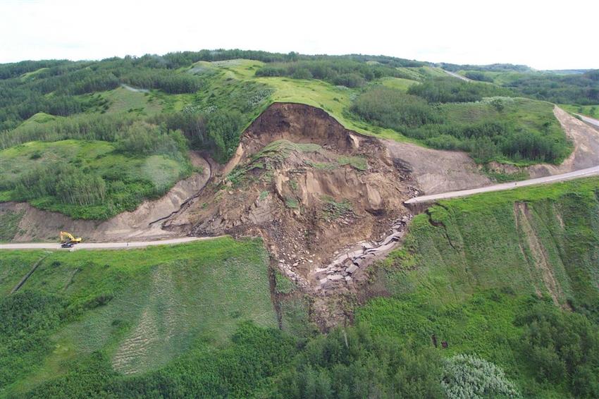
To gain better insight and as an example of projects funded, please read a summary of 3vGeomatics' proposal to develop a monitoring system to detect landslides in wide areas. (Credit: R. Couture/Geological Survey of Canada)
Explore further
- Funding programs and opportunities
- About the Earth Observation Application Development Program
- Earth Observation Application Development Program
- Date modified: